Whitney “Allgood” LaRuffa: Continental Divide Trail


About the Continental Divide Trail

The Continental Divide Trail, or CDT as it is known in the hiking world, is a 3,100 mile trail that follows America’s great divide. This trail is the longest of the main 3 National Scenic Trails that make up the “Triple Crown” of long distance hiking, the other two trails being the Appalachian Trail 2,180 miles and the Pacific Crest Trail 2,650 miles. The CDT is not only the longest of the 3, it is also the highest as it follows along the Rocky Mountains. The CDT’s highest point is Grays Peak in Colorado, at 14,270 ft. The trail itself hikes through 5 states; New Mexico, Colorado, Wyoming, Idaho, and Montana. The trail crosses deserts, high alpine regions, and some of the best scenery and wilderness found in the lower 48 states.
The CDT is not yet complete and currently only 72% of the trail is actual trail, about 95% of it is marked, and the rest of the length one travels during a thru-hike is on roads and cross country. Each year roughly 150 people attempt to thru-hike the CDT, hiking the entire length of the trail in one hiking season. In 2016, I successful thru-hiked the CDT, a dream I had harbored for over 20 years finally became a reality.
Difficulty
This trip varied greatly in difficulty from leisurely walks along dirt roads to extreme snow travel across the Southern San Juans in CO. There were multiple sections of cross country route finding and bush whacking through sage brush and forests killed off by pine beetles.
Maps/General Information
I used a combination of navigational aids for the trip. I carried a paper set of Jonathan Ley Maps for the trail which provide numerous alternates along the trail. On the technology side, I used three Apps on my iPhone for navigation. Guthook’s CDT App and Avenza PDF maps helped show me mileage, water, and navigation along the route. I also used the Gaia GPS App which allowed me to download large overview maps along the corridor I would be traveling.
Resupply
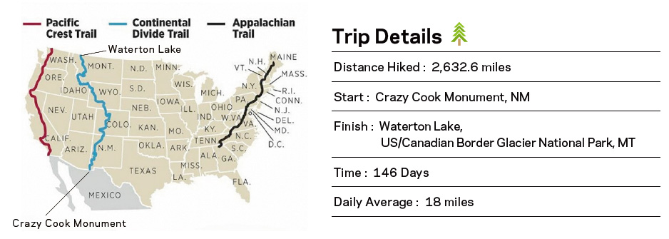
Along the CDT there are numerous towns and remote outpost where one can resupply by either mailing themselves a package or purchasing provisions along the way. I opted to mail myself packages, mainly as a way to save money and ensure I had what I needed. It also allowed me to utilize my generous sponsorships from Backpacker’s Pantry, Salazon Chocolate and UGO Bars. The longest food carries I had were 6-7 days, however most food carries were 3-5 days depending on our location.
Wildlife
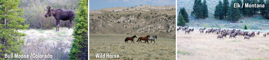
The CDT passes through so many various environments that the wildlife varies as much as the terrain, Along the CDT I encountered: rattlesnakes, bull snakes, pronghorn, elk, moose, big horn sheep, grizzly bears, marmots, pikas, golden eagles and just about every critter one could imagine in the Rockies.

Leaving one’s life behind for 5 months in their late 30’s is no easy task, let alone when you have a home, a wife, and a dog. The first stage of the preparation was leaving my career of 16 years as a lumber broker. Before leaving my job, I worked for a few years at curbing my spending and saving enough money to allow me to fund my hike, pay the bills at home and have a safety net for my return to life.
Once the finances were squared away and I left my job, my loving wife Suzy handed me a 2 page "honey do list" of things that needed to be done at home before I departed. I worked on each task while packing away my life into boxes in our basement. Then I spent 3 days preparing the 22 boxes that would be mailed to me along the way, labeling them and filling them with food, snacks, extra batteries, sunblock, and extra items I would need to replace.


I spent a few days in Silver City, NM acclimating to the elevation since I live at sea level and also celebrating the CDT at their annual Kick Off event. I had the honor of speaking at the event about thru-hikes for the working stiff, which are short hikes of 100-200 miles that one can do during a two week vacation period. After a weekend of fun, seeing old friends and meeting new ones, it was off to Lordsburg, NM for our shuttle ride to the Border.
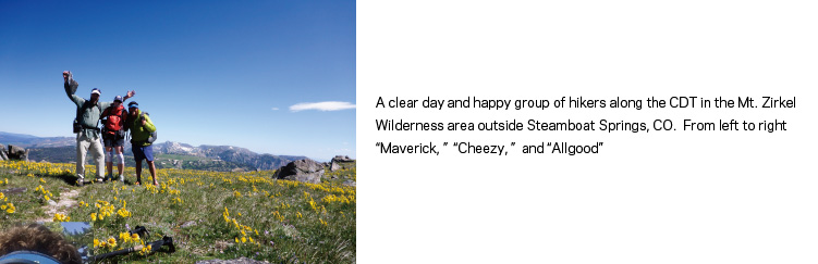
PHOTO: From Left to Right “Allgood,” Teresa Martinez with CDTC, and Greg Wozer of Leki. CDT Trail Days is a fun event where participants can take time to try their skill with a cross cut saw and fire brand to make their own CDT marker to take home
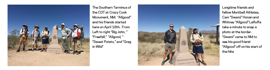
I started the CDT with 4 of my friends from Portland, Oregon. “Freefall” and "Sweet Potato” were planning to hike NM while “Big John” and “Greg in Wild” were planning on thru-hikes of the trail.
Early in the morning, with the sun yet to rise over the desert we loaded into a dodge truck for the 3 hour drive over a rough dirt road to the border with Mexico. As a bonus for my sendoff, fellow Montbell athlete and my dear friend Cam Honan had arrived to see me off to the border all the way from Australia after just completing his traverse of Tasmania.

For the next few days we acclimated to life as desert travelers, we awoke before sunrise, hiked for a few hours in the dark and early part of the day until around noon. When the sun was at it’s apex we would find some sort of shade, whether it be a wash with brush overhead, a lone juniper tree, or the shade of a cattle tank. We would lie down and rest until around 3 or 4pm when the heat had subsided and we could carry on with our hike for the rest of the day.
By the time the first 90 miles had passed under our feet we arrived back in Lordsburg, stronger and with hard earned knowledge of how to go about our days ahead in NM’s deserts and mountains.
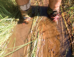
PHOTO: Taking a break during the brutal mid-day heat of the desert in small grove of trees by a spring. With limited shade from the sparse trees “Allgood”, “Buttercup,” and “Freefall” employ their Montbell umbrellas to help provide extra relief from the sun.
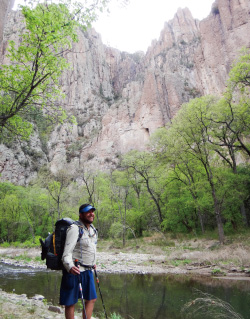
The next part of NM was as different from the desert as you could imagine. After hiking through the Burro Mountains and the town of Silver City, we entered the Gila River Canyon.
This is just one of many alternates the CDT hiker can choose along the hike. We opted to descend into the canyon for the next hundred or so miles, walking through towering cliff walls and crossing the Gila River over 250 times. Along the Gila we visited the Gila Cliff Dwellings where Mogollon Peoples lived and enjoyed long soaks in hot springs.
PHOTO:“Allgood” in the Gila River Canyon, one of the highlights of the CDT in NM. With over 200 river crossing throughout the canyon, this hike up the middle fork posed a nice break from the desert heat.
The Northern half of New Mexico found us in Mesa, country with sculpted sandstone formations and varying weather conditions, from morning temps below freezing to hot sunny days that kept us moving through pine forest and into the mountains.

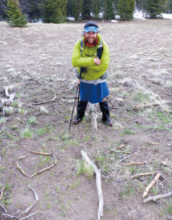
As we made our last push through New Mexico we got our first taste of what lay ahead in Colorado. Snow. And lots of it. At Ghost Ranch, the final resupply in New Mexico, I received a new pair of knee high Gore-Tex gaiters. These well needed gaiters helped protect my legs from the endless postholing we encountered on the last two days of our time in New Mexico.
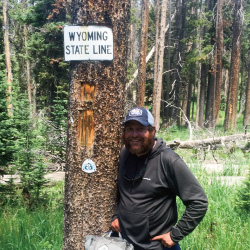
Our time in New Mexico ended when we crossed the state line and camped our first night in Colorado, high above Cumbres Pass. We found the only bare ground available under some trees and spent a cold night gazing at the Southern San Juan Mountains that were blanketed in snow.
PHOTO:One state down and four more to go! A very happy “Allgood” stops at the makeshift border crossing to celebrate successfully finishing his first state of the CDT.

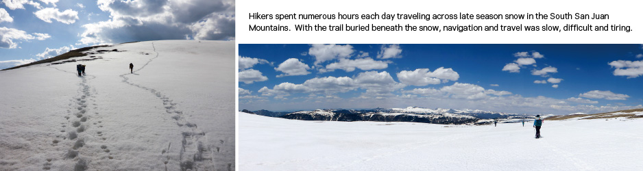
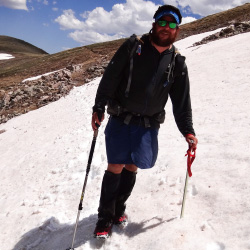
Chama, NM lies just down the highway from Cumbres Pass, even though we had arrived in CO we had to drop back into NM for our resupply. The next 240 miles of the CDT travel through the San Juan Mountains, a late snow pack and above average snowfall made this section one of the hardest and most dangerous we would face. In Chama we all retooled our kits to include items for snow travel. Each of us received a large box or two that contained what we needed: ice axe, snow shoes, micro spikes, extra layers, and so forth. At this time I swapped out my 850 down parka for a therma-wrap, I wanted to have an insulation layer I could hike in, get wet and still keep me warm. Besides the snow we would experience what Colorado’s mountains are famous for, daily thunder and lightning storms along its high ridges.
The first 90 miles from Cumbres Pass to Wolf Creek Pass were some of the hardest, coldest, and most rewarding miles I have ever hiked.
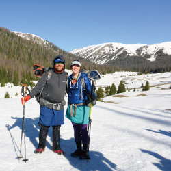
Liz Thomas joined me for a few weeks and together along with 7 others we walked over snow, postholing even with snow shoes, traversing steep gullies, and walking past large blocks of snow from recent slides that sent shivers down my spine. One day we decided to drop low to avoid a very treacherous ridge, however this alternate required us to harrowingly ford across three very cold, river forks. We worked as a group, sticking together, and helping those with less experience get through the steep sections. By the time we hit Wolf Creek Pass, we were exhausted and had to formulate new plans going forward.
PHOTO:“Allgood” and Liz “Snorkel” Thomas take a quick photo in a clearing among the snow in the South San Juan Mountains of Colorado. With a late snow pack this section of trail was more of a snow traverse through the high country than a hike.
I decided to take the Creede Cutoff, this alternate cuts off the horseshoe the trail makes through the San Juan Mountains, it was not easy however. We had to travel through an old burn area and the river crossings were difficult with all the spring snow melt. After Creede things got a little easier, we enjoyed the Cochetopa Hills, and this lower elevation stretch rewarded us with numerous moose sightings.
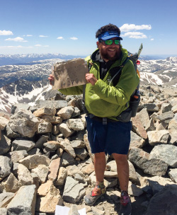
We slowly worked our way north through Colorado. A highlight of the state for me was the Argentine Spine, which travels for 20+ miles along a high, narrow ridge in Colorado and ends at the high point of the CDT at Grays Peak at 14,278ft.
Besides Grays Peak we had the honor and pleasure of ascending and descending many peaks along the spine that were between 13,000’-13,900ft.
PHOTO: “Allgood” is all smiles as he stands atop Grays Peak (14,278ft), the highest point along the CDT.

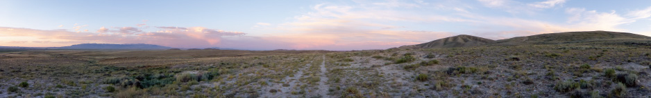
We entered Wyoming in early July and the snow was finally behind us along with the higher elevations we had been in for the past month. The first challenge in Wyoming is the Great Divide Basin, also known as the Red Desert.
This basin is created by the geological split the Continental Divide makes here in Wyoming. The Divide splits to a far eastern and western range, leaving a low elevation desert in between.
The Great Divide basin was fairly gentle for me, some cloud cover came in keeping temperatures cool during my traverse. Besides the endless landscape of sage brush and rolling hills, the basin is home to thousands of pronghorn (antelope) and herds of wild mustangs.
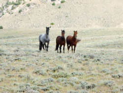
On many occasions I stood in awe as a herd of wild horses ran past me, the American west at it’s finest.
After the Basin we entered into the Wind River Range, one of the most stunning places along the CDT.
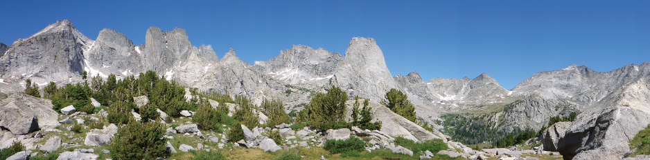

These granite peaks reach for the sky out of the desert and are home to numerous lakes, ponds, and rivers. One of the alternates I did was into the Cirque of the Towers, one of the most amazing cirques I have ever seen. As we neared the north end of the Winds, a large forest fire had erupted and filled the sky with smoke. When we reached Gunsight Pass my hiking partner and I learned that the trail was closed and that Union Gap Road, which we had planned to use to walk around the fire, had been evacuated. The group that told us this showed us an alternate we could take to walk into the town of Dubois, WY. We walked up the closed road, then used a network of decommissioned roads and ATV trails to reach town. The night before reaching town we slept in a large open area by a marsh and less than a mile from camp we watched the forest burn. All night I watched as one tree after another went up in a ball of flames, ash raining down on our tents. As soon as we felt rested enough we packed up before dawn and hiked as fast as we could to town.
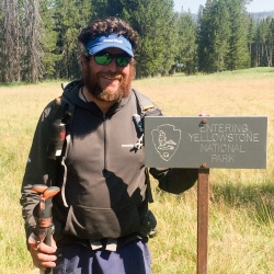
The last stretch of Wyoming was through Yellowstone National Park, one of my favorite places in the US.
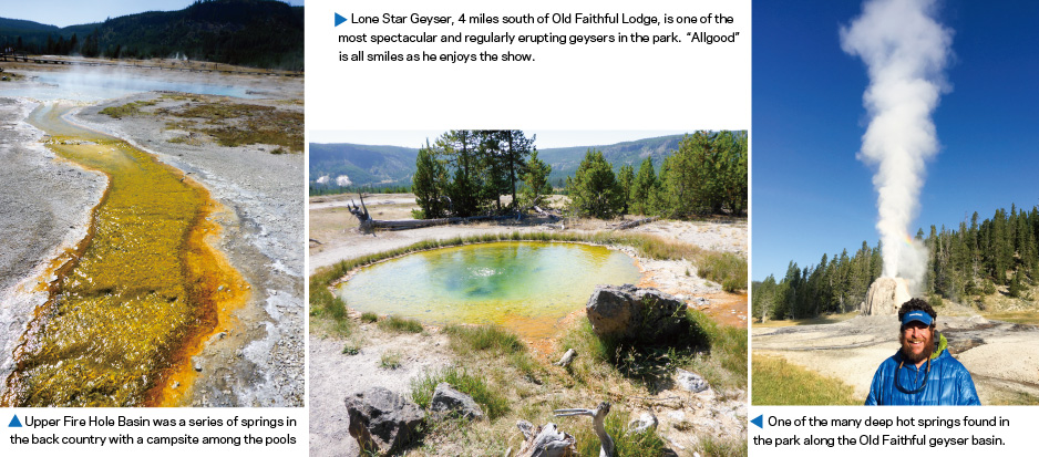
For the next 4 days we walked through geyser basins, past hot springs, and other geothermal wonders. We made a side trip one day to Lone Star Geyser. This large geyser is 4 miles from Old Faithful, erupting every 3 hours for about 30-45 minutes shooting water 45-60 feet in the air. We sat there as the sun rose, just 4 of us, and watched the geyser come to life. It was awe inspiring and peaceful. This time spent with just 3 other hikers was for me, the highlight of Yellowstone. When we reached Old Faithful Lodge later that morning, my hiking partner of over 1,000 miles “Cheezy” and I said goodbye and hiked our own ways. “Cheezy” opted for the 350 mile Butte Super Cutoff to save herself time to finish in season, while I opted for the official CDT and decided to increase my daily mileage to finish on time. It was a sad day for me, “Cheezy” and I had grown close like a brother and sister and after all of our times spent running from lightening, fording raging rivers, postholing through snow, crossing deserts and a variety of other experiences, it was hard to not go on together.

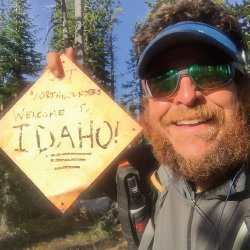
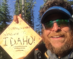
The final leg of the CDT was probably my favorite of all. For a few hundred miles I traveled along the Idaho and Montana Border. The trail mainly follows the spine of the Beaver Head Mountains and takes you up and down countless small mountains. The border region is a mix of high desert with sage brush and grasses, transitioning into a ponderosa pine forest. This region is home to grizzly bears and countless elk.
PHOTO: Now on his own, “Allgood” stops to snap a selfie at the Idaho Border. For the next few hundred miles the CDT criss-crosses the ID/MT Border.

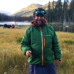
One evening after leaving my resupply in Lima, MT, I came across a herd of elk numbering in the hundreds. For over a half hour I slowly walked and watched groups after groups of elk come pouring out of the woods, cross the valley I was in and run up the next mountain. It was one of the moments that leave a hiker speechless and really makes one appreciate how wild the Rocky Mountains are.
PHOTO: A large herd of Elk spilled from the forest in front of “Allgood” outside of Lima, MT.
This region is not only wild and a string of wilderness areas but it is also rich in US history. Many of the passes I crossed were passes that Lewis and Clark used during their expedition to the Pacific Northwest. In remote regions of Montana I would come across historical signs talking of their Native American guide Sacagawea, or a pass they used to cross over into the Columbia Basin. The area was also rich in history of the settling of the west, and the Native American Wars of the Blackfeet and Nez Pearce tribes, and the atrocities they faced at the hands of the US Calvary, a sad history indeed but one I am glad I learned more about. In all, this stretch of the CDT was as much a wilderness experience as it was a living history lesson.

After walking hundred of miles through high desert hills and the Anaconda Pintler Mountains, we came to Helena, MT, the last town I would see until I reached East Glacier some 350 miles away. This area was rugged with many steep up and downs, exposed ridges, and the final stretch through what could be called high desert until I reached the Bob Marshall Wilderness. This leg of the hike had me carrying 7 days of food at a time and being late summer most of the water sources were low or dry. So I was also hauling about 4 liters of water most days.
The Scapegoat Wilderness was a wild stretch with no roads and no people, leading me into the Bob Marshall Wilderness, one of the largest roadless areas in the US. The night I was approaching the Bob Marshall, I turned to my hiking partner as we strode along the trail and said, “That stump looks like a bear.” As the words left my mouth, a giant grizzly turned and sprinted up the hill in front of us like an Olympic sprinter.
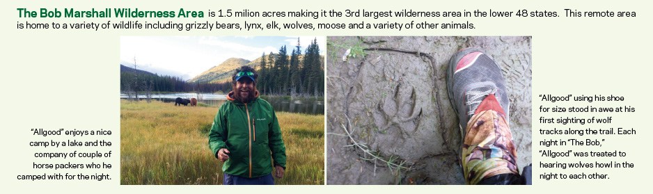
This area was a real wilderness treat. Every day I saw bear and wolf tracks, and each night as I lay down, I would hear wolf packs calling to each other off in the distance.
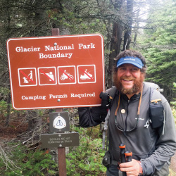
My final leg of the CDT was in Glacier National Park, the crown jewel of the Continent.
Glacier is a place of beauty and awe inspiring views. The day I started in to the park, the weather took a turn for the worse. As I walked into the park snow was mixing with rain in the lower elevations, but when we reached the passes we were greeted with snow. For the next few days I walked past places like Two Medicine, Many Glacier, Piegan Pass and many other spots that make Glacier famous.
PHOTO: The smile says it all. After months hiking North, “Allgood” finally reaches the border of Glacier National Park and the last stretch of the CDT.

I saw a total of 4 more Grizzly bears in the park and feasted on ripe huckleberries. Finally just shy of 5 months I walked along the shore of Waterton Lake and reached the US/Canadian boundary marker and the northern terminus of the CDT.
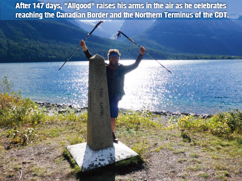

After 20 years of dreaming of walking from Mexico to Canada along America’s Great Divide I had achieved my dream and felt a sense of pride I have never experienced before.
PHOTO: After days of rain and snow, the clouds parted at Waterton Lake revelaing a blue sky for “Allgood’s” last 4.5 miles of the CDT. With the air temperature still below freezing “Allgood” is bundled up in all of his layers to stay warm for the final push to the border.

Whitney “Allgood” LaRuffa
Whitney has hiked over 6,000 miles with his K-9 companions over the years. After finding a dog on the Appalachian Trail in 1996 his life was forever changed. Whitney and his first dog Erwin (named for the trail town Erwin, TN) worked on the Appalachian Trail in the 1990’s as Ridge Runners after their thru-hike, where they provided education and support to a variety of trail users. Whitney has hiked many long trails in the US but is most proud of his recent pioneering first thru-hike of the Chinook Trail, a 293 mile route through the Columbia River Gorge in WA&OR.
>>>about Allgood
CDT Blog: http://thedagodiaries.com/
Homepage: http://www.allgoodsk9adventures.com/
Facebook: http://www.facebook.com/AllgoodsK9Adventures/


Tachyon Anorak
This one top is by and large the most well used clothing item in my pack. At just 2oz it's light and easy to pack. I often put it on during a break to conserve my body heat and energy. It also was the perfect layer on a windy day or sitting atop a high peak in Colorado when eating a snack.
Dynamo Wind Pants
These 1.9 oz pants are one of my favorite leggings of all time. The fabric cut the wind perfectly, were a welcomed extra layer on rainy days, and virtually replaced rain pants for me most of the trip. After 5 months, they held up well with minimal wear and from now on will always be in my pack.
Torrent Flyer
My favorite rain jacket is light and packable. I put this jacket through the paces more than once and every time it kept me warm and dry. Through rain and snow, time after time, this jacket not only held up to the elements, it breathed well when I was exerting myself.
Superior Down Parka
A great down jacket, light and warmer than I expected. I used this jacket mainly in the early mornings and evening at camp to keep me warm. I also often slept in it for extra insulation on especially cold nights.
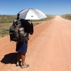
Sun Block Umbrella
The umbrella was key for me not only on rainy days in Montana, but more so on the sunny days in the desert. One day it was the only shade I had while walking across the Great Divide Basin, helping keep me cool and protected from the sun.
-

Sun Block Umbrella 55
Price: $65.00
Cool Hoodie
This lightweight, fast drying top was my go to during my hike. Its long sleeves and hood helped protect me from the sun. Even with infrequent washes during long stretches I found the fabric stayed soft against the skin no matter how much salt and sweat had built up on it.
Merino Wool Top
I generally do not like wool tops, but this merino wool layer was so soft I hardly realized I was wearing it. I used this top as a standalone layer in Northern New Mexico and then as my base layer for extra warmth in Colorado. It not only held up well after days of constant use, it lived up to its reputation of not holding in smell.
Beanie
One of the softest and warmest hats I have ever had the pleasure of wearing. This beanie stayed in my pocket to warm my head during the day and I slept in it each night since my quilt did not have a hood.
Gore-Tex gaiters
These lightweight Gore-Tex Gaiters were just what I needed when postholing to keep snow out of my shoes and protect my shins from any cuts from the snow crust. The waterproof zippers were bomb proof and made taking these on and off an easy task.