Heather "Anish" Anderson: Bartram Trail

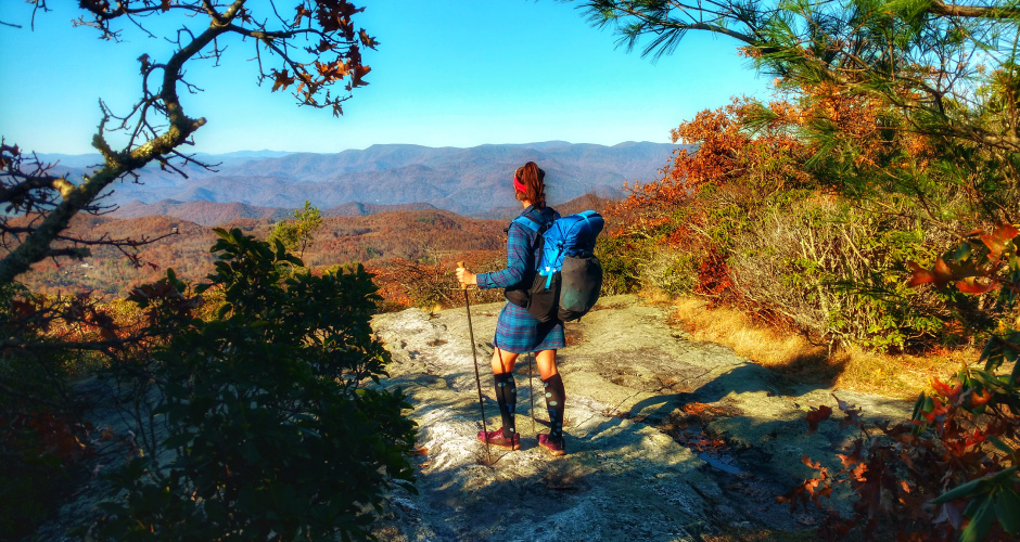


The Bartram Trail is approx. 115 miles long and retraces part of the exploratory route of 18th century American naturalist, William Bartram. The trail’s southern terminus is on the Georgia/South Carolina State line near the Chattooga River (famous for its part in the movie Deliverance) at a place called Russell Bridge on Georgia State Route 28.
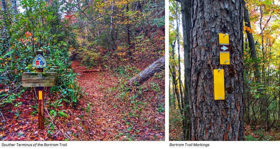
Its northern terminus is atop Cheoah Bald in North Carolina, which is a summit on the Appalachian Trail. You have the option to hike out to a road on the Appalachian Trail (as we did) or retrace your steps back down the Bartram. There is no road access to the Northern Terminus. Overall, the Bartram is marked consistently with yellow blazes as well as an assortment of wooden signs, carved rocks, and brown arrows. I hiked with my husband and we saw few other trail users.
Trip Details:
Distance Hiked: 123 miles (including 8 miles of the AT to reach the road at the Nantahala Outdoor Center)
Start: Russell Bridge Trailhead, GA
Finish: Cheoah Bald, NC
Time: 5 days
Daily Average: 25 miles
Difficulty:
The route is well marked with plentiful water and multiple roads to access resupply points. In typical Appalachian fashion it ascends and descends multiple short climbs in quick succession, making it intense as far as elevation gain and loss. There is also a 14-mile road walk in the middle, as well as another shorter one near the end which some people skip. We walked it and found it to be a rather pleasant rural road section.
Maps/Navigation:
We utilized a GPX file found online as well as a detailed (albeit slightly inaccurate) trip report online: http://www.trailquest.net/BRbartram.html. The trail was sufficiently marked with frequent cell phone access so navigation was easy.
Resupply:
We chose to resupply only one time in Franklin, NC which the 14-mile road walk takes you through. We opted to simply buy groceries at the store and stay at a hotel and finish the road walk to the trail the next morning. This split our carry into a 2 day carry and a 3 day carry.
Wildlife:
Contrary to popular belief, the Appalachian Range is teeming with wildlife. I have found more diversity on my hikes in the Wild East than on western trails. The Bartram Trail was certainly no different, starting with the bobcat that ran across the road on our way to the trailhead and including numerous Eastern Coyotes (coywolves), several species of owl, salamanders, snakes, as well as plenty of songbirds and deer.

Section 1: Georgia
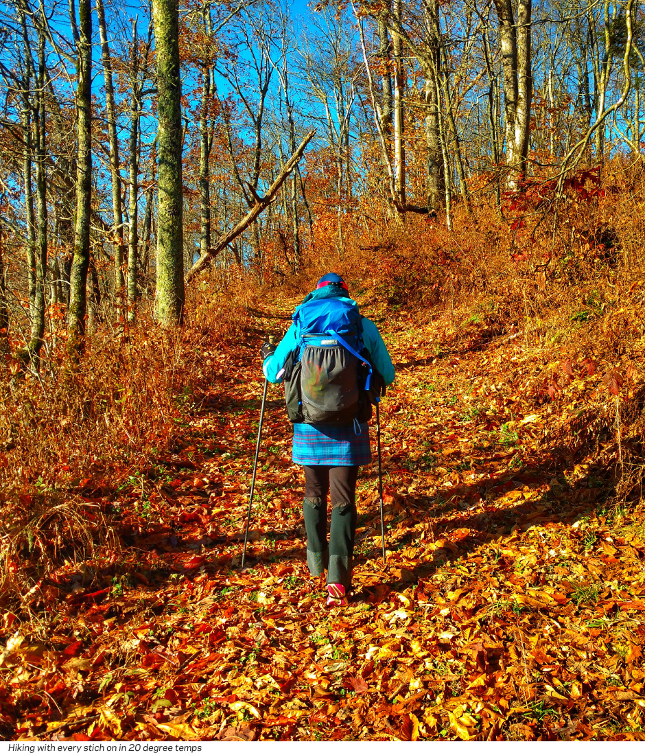
The Georgia section of the Bartram trail is only about 38 miles. We started late afternoon and with the very short daylight of hiking in mid-November, found ourselves hiking along a winding ridgeline in the dark and low on water.
Although the first miles traversed gentle lowlands along the Chattooga River, we neglected to get water at a small tributary before we ascended up to a traversing ridgeline. This was the one case where not having detail guides made for a bit of trouble. However, the very cool temperatures made it easy to walk 7 miles the next morning to the next water source without any difficulty.
Our first full day on the trail, we dropped down through War Woman Dell and then ascended the lovely riparian areas surrounding Martin Creek and its falls.

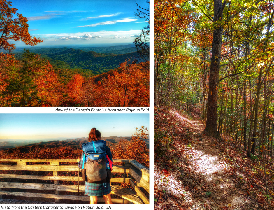
The day was essentially all climbing until we reached the Eastern Continental Divide atop Rabun Bald. We watched the precursor to sunset from the viewing platform, drinking in the gorgeous color of late Autumn in the Southeast.
We descended from the second highest point in Georgia and made our way in the dark across the North Carolina line and found a nice camp several miles into the state.
Section 2: North Carolina Border to the Appalachian Trail (Wayah Bald)
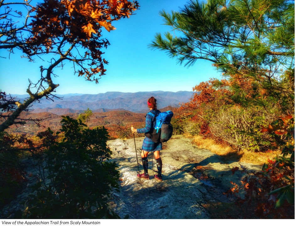
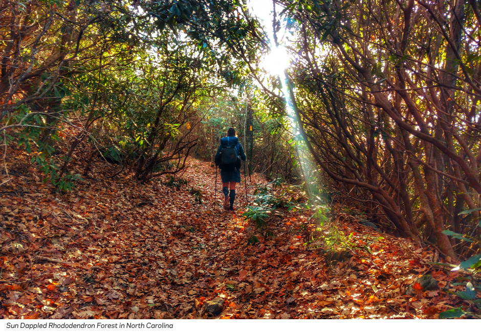
The morning was perfect: cool, but not cold and we enjoyed climbing up to Scaly Mountain, which was far lovelier than the name suggests. Sunlight dappled the rhododendron forests and gave the hike an altogether magical feel. We enjoyed views across a wide valley to the ridgeline the Appalachian Trail traverses. It was a nostalgic and special moment since between the two of us, we have 4 AT thru-hikes.
The rest of the day was very reminiscent of the Appalachian Trail as we descended and ascended, sometimes steeply, through multitudinous gaps and over and near summits of several other mountains: Hickory Gap, Jones Gap, Whiterock Mountain, Fishhawk Mountain. Finally, we began to follow the top of a ridgeline leading to Wolf Rock and beyond. This would be our warmest day on trail with highs in the 70’s and quite sunny. Due to the ridge-y nature of this section, we were also quite thirsty and wishing that there were a few more water sources.
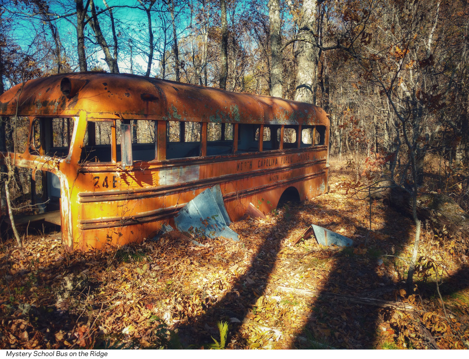
We reached the panorama at Wolf Rock in the early afternoon and decided that we did indeed have time to make it all the way to Franklin that day. The desire for a shower and a hotel was strong. We descended along the ridge from Wolf Rock, passing a derelict school bus (who’s arrival on the narrow ridge was a mystery) and the old route that dropped steeply down the western side of the ridge.
We opted instead to follow the recently completed trail that maintained its trajectory northeast along the ridgeline for several more miles before dropping down to the road in what was essentially someone’s driveway.
We reached the pavement, glad we’d chosen to push to town since our original plan had been to camp at the trailhead, which was impossible due to the steepness of the trail (stairs) and the proximity of a home and drive. We continued our hike along the paved roads that wound their way down toward Franklin. Initially we debated whether we’d take a ride if it was offered or if we wanted to hitch around this section, but soon we realized that although the road didn’t have any shoulder, it also didn’t have a lot of traffic. Most of the homes were set well away from the roadway and we were only chased by one set of dogs. They were terrifying, but we shouted and waved our trekking poles at them which kept them at bay while we passed out of their perceived territory.
We reached town at dusk and dashed across the busy roadway into the grocery store that was right across the street. We bought our resupplies and headed up the road to the Microtel where we feasted on Wendy’s and enjoyed hot showers and a comfortable bed. We’d known the weather the next day was going to be bad, so walking out of town we were pleased that although overcast and cool, it was not yet raining. We’d hiked 10 of the road miles the day before, so the last 4 out of town to the Wallace Branch Trailhead passed quickly. The remainder of the day was spent ascending the long ridge trending up to the Appalachian Trail and Wayah Bald, the high point of the Bartram Trail.
We made a slight wrong turn in the rhododendron forest as the fog began to roll in and found our way back to the Bartram just as it began to rain. We reached our intended campsite at the junction with the Appalachian Trail (which we’d follow several miles concurrently with the Bartram) just below the summit of Wayah Bald to find that it had been closed for rehabilitation. Upset, we pressed on as the icy rain began to pour. We could have walked out of our way on the AT to utilize the shelter, but didn’t want to add miles. We thought we could find a campsite soon, however we’d both forgotten the traversing nature of the AT south of Wayah Bald. There was no view on the summit and we were sad to miss one of the best panoramas of the south. We pressed on several miles until we finally found a campsite near where the Bartram and Appalachian Trails split.
Section 3: Wayah Bald to Cheoah Bald
We woke to a completely frozen tent. The heavy rain had turned to freezing rain as the temperatures dropped into the 20’s. A thick layer of ice coated the entire tent and the ground around us. Our shoes, backpacks, socks, gaiters and rain jackets—everything that had gotten soaked while we hiked in the storm—was now frozen solid.
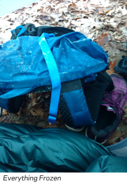
We dallied, drinking coffee and wishing that it would magically warm up. Inevitably, we had to leave the tent. I remained in my fleece sleep clothes, layering my hiking clothes and lastly my frozen rain jacket over top. I managed to wriggle my feet into my frozen socks, but I could not get them into my frozen shoes. Despite leaving them unlaced and propped open, they were too stiff to get on. After several minutes of banging my cold feet, encased in frozen socks, against the shoe opening trying to force them in, I was in tears. Finally, my husband was able to soften the uppers with his hands. They crunched and bent. Then he forced my feet into them while I held on to his shoulders, crying with the pain.
Once we were moving the heat of my body warmed the shoes enough that within a couple miles, they were malleable again. My feet were still frigid, but at least not in pain. We left the Appalachian Trail far behind as we followed a west trending ridge toward Nantahala Lake. The day was sunny, even though it was cold. The dry air and sunshine thawed our frozen gear and we enjoyed beautiful vistas from the narrow ridge.
We made our way down steep trail covered with a foot of fallen leaves (making for slippery footing) to the short road walk along the SR1310. We stopped at a sunny pull off and rearranged our layers, drying our tent in the sun.
We resumed walking on the road, looking forward to the Phillips 66 Station that was supposed to be about a mile down the road. After a frigid night and morning, I was eager for hot coffee and some treats. Unfortunately, the people at the convenience store were rude and unwelcoming. Feeling a very distinct pressure to leave, we did…without any treats or coffee.
This colored our mood as we made our way through the next few miles, which can be best described as “connector” miles. We wound our way along old logging roads, near private property, and past obvious party spots complete with bullet holes and tin cans. We popped out on a dirt road where some people were cutting fire wood. They openly stared at us as we went by. Next, we crossed the cement bridge/roadway across the Nantahala River. During high water this is impassable by foot. Luckily, only a trickle of water was flowing across the roadway and we were able to continue on our route which followed a remote gravel road. There were quite a few cabins along the way, but they mostly seemed to be unoccupied for the winter.
Two miles later we reached the paved SR1401 and followed it a short distance to the resumption of nice trail tread which took us along the river and through the outskirts of the Appletree Campground where we gratefully disposed of our accumulated trash in the receptacles.
The rest of the day we wound up and down along the river, sometimes near and sometimes quite far from it. Normally adverse to the PUDs (pointless ups and downs) the crisp air and thick leaves made it a playful romp. After the unsettling connector section, we were also thrilled to be on trail again and away from the stares and unwelcoming vibe near the lake.
The map at the kiosk for Appletree Campground had assured us of two campsites in the vicinity of where we hoped to stop for the day. As evening approached, we had to agree that neither of the campsites had actually existed since we were long past both of them. The trail was again sinuously traversing a long ridge, making it impossible to make a camp. As darkness fell and we were pitching our tent across the trail, where the crossed a shoulder of a bisecting ridge and grew just wide enough to accommodate us, I regretted my joke from earlier in the day: “It’s not a thru-hike unless you end up camping in the middle of the trail.”
We woke our last morning to brilliant sunshine and considerably warmer temperatures. We took our time enjoying a leisurely hot breakfast and coffee, reflecting on our solitudinous autumn thru-hike before packing up and finishing our descent to follow SR1310 yet again. In the process of packing up our unorthodox camp and ensuring no damage had been done to the surrounding area, my husband left our tent stakes sitting on a rock. We realized it later in the day when we set out our tent to dry. Luckily, we’d already arranged a ride back to Asheville and wouldn’t need to set it up again on the hike!
A few minutes down the trail we passed by a huge green surge tank and then followed a gravel road for the next couple of miles to the 1310. We reached a trailhead near a large substation and merged onto the paved Mountain-to-Sea bike path. A mile and a half down the bike path we crossed Highway 19 at the Winding Stairs Trailhead and began climbing steeply up through the forest.
Eventually the grade evened out, although the rest of the trail remained a grinding ascent. There are no easy ways to climb Cheoah Bald! We crisscrossed lovely Ledbetter Creek all the way up the valley before leaving it and climbing steeply up Little Bald Mountain. Shortly thereafter, we again intersected with the Appalachian Trail and followed its white blazes southbound less than half a mile to the end of the Bartram Trail on the summit of Cheoah Bald.

We lounged in the sunshine and dried our tent. We ate a celebratory lunch (although we didn’t have much of anything left at this point) and took pictures with the Cheoah Bald sign and the view.
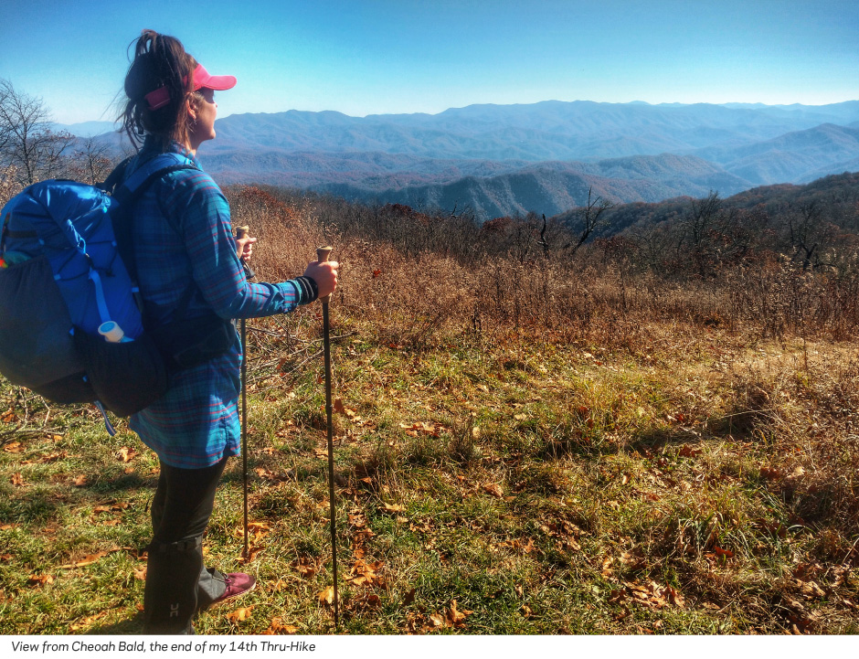
There unfortunately is no northern terminus sign for the Bartram Trail here. After about an hour, we made our way down the Appalachian Trail to the Nanatahala Outdoor Center where we had a delicious dinner celebrating the completion of my 14th thru-hike before our ride picked us up and returned us to Asheville.

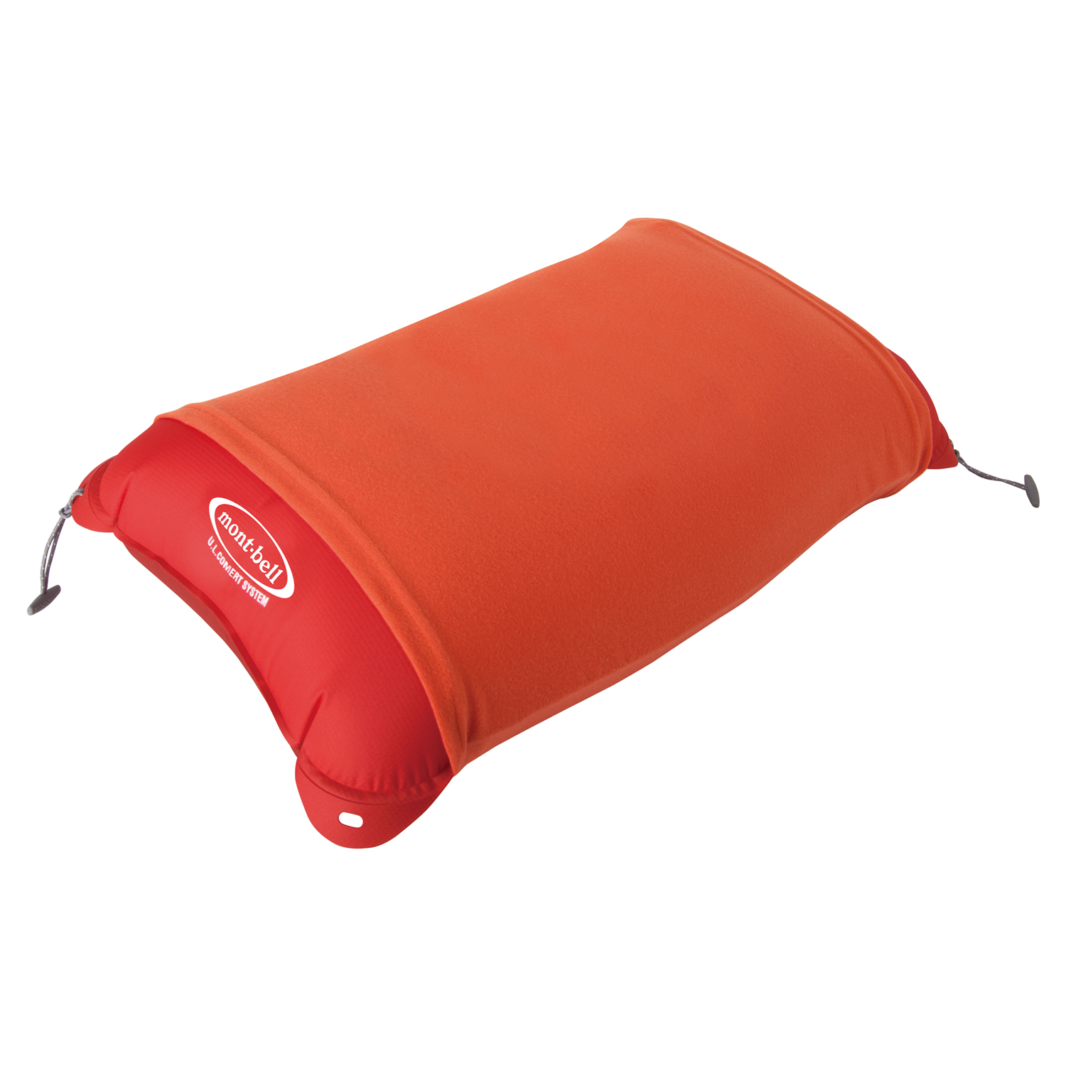
U.L. Comfort System Pillow
My trusty backcountry pillow

DOWN SLEEPING WRAP #2 LONG
My first experience with a quilt. Aside from the night of freezing rain, this was adequately warm with nighttime lows in the 30’s and 40’s.

Alpine Pad 25 150
The perfect cross between warmth, cushion, and weight. Especially in colder months, I find that an inflatable pad is better than closed cell foam alone.

Micro Towel Hand
All purpose

Wickron Cool Visor
This was useful on the very sunny days since some of the leaves were already off of the trees. It was light enough I didn’t mind carrying it on the overcast days.
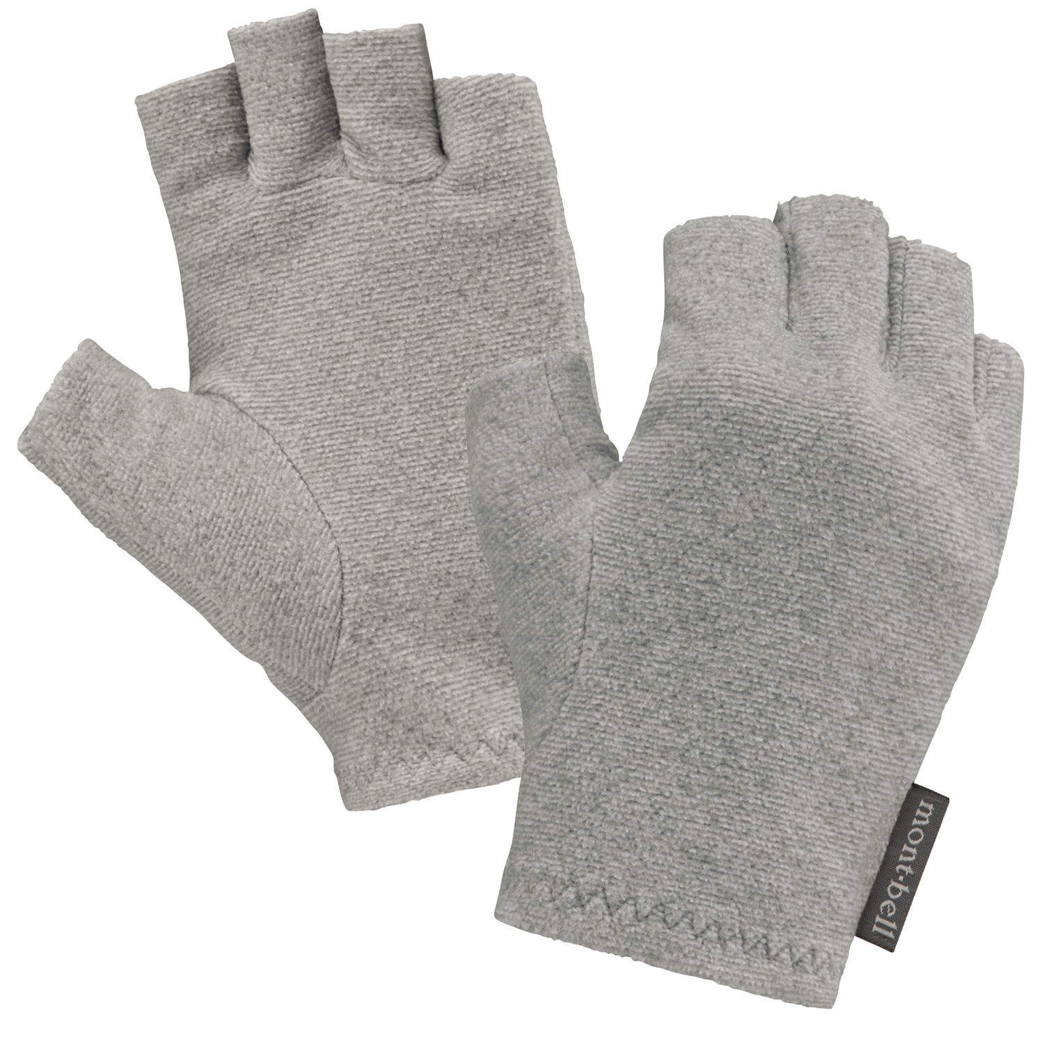
Chameece Fingerless Gloves Women's
My all-day gloves, cool enough to wear dawn to dusk. Warm enough to keep my hands comfy in the brisk weather.

Wickron O.D. Shirt One-piece
The true MVP of the trip. This long sleeve dress was perfect for the weather conditions. Properly warm without causing me to overheat, except for the one day that was in the 70’s. Layered with other items it transitioned from hiking in 30-degree temperatures to 60’s all very comfortably.

U.L. Thermawrap Jacket
My go to insulating layer this jacket was perfect for cool mornings and evenings. I wore it every day. Wind blocking, insulating, and warm even when sweaty this jacket went far beyond expectations.

Storm Parka
We’d known that we were going to have one day/night of cold, pouring rain and so I opted to bring a substantial hard-shell rather than a lighter rain jacket. The length of the trail combined with our low mileage days meant I was willing to carry some heavier items in order to have more comfort. While hiking for an hour in 35-degree rain, I was incredibly thankful I brought this parka!

Climapro Watch Cap
The water-resistant wind-proofness of this cap made it versatile in the range of conditions we faced. It also dried fast, which was essential the night it poured.

Tachyon Parka
This ended up being a superfluous piece since the One Piece Shirt dress performed so admirably. I wore it the morning of the frozen gear as a vapor barrier between my frozen Storm Parka and my dry clothes, but otherwise it was a couple ounces of emergency gear.

Peak Shell Pants
Again, an item I carried in anticipation of the torrential rain. Since we had to hike for an hour in those conditions, having these mitigated hypothermia risks and kept my dress and wool tights dry enough to sleep in that night.

Super Merino Wool L.W. Tights
Perfect for the cool mornings and the last hour or so of hiking in the day, these were a perfect complement to the Wickron O.D. One Piece Shirt dress that I hiked in.